


| Location | Description | Products | |
|---|---|---|---|
| Call for ideas 2020 (data October 2014 - end of April 2021) | |||
|
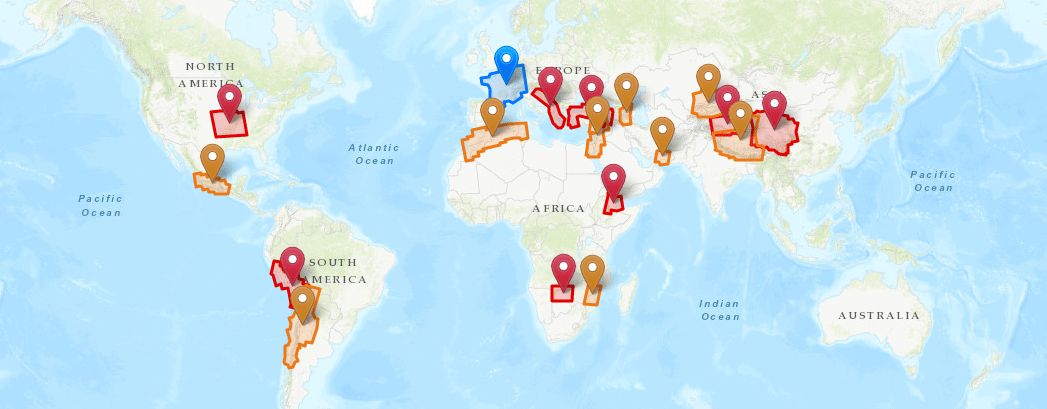
Afar
|
This project aims to characterize the spatial and temporal distribution of the deformation in the region of the Afar depression. The aim is to better understand large-scale tectonics (localization of divergent borders, kinematics of the triple point), but also the dynamics of volcanic, seismic and aseismic events, and the mechanics of active faults. The issue of gravity hazard will also be addressed.
Themes:
Landslides, Tectonics, Volcanology
Project leaders:
R. Grandin (IPGP)
|
Access to products | |
|
Central Andes, Peru-Chile
|
This project aims to better understand the seismic cycle of the Andean subduction zone in Peru and Chile and the crustal faults in the Andes, to follow the functioning of the large active volcanoes in the region (and to detect possible precursors to eruptions) , and to study the seismic, climatic and anthropogenic forcing on the dynamics of landslides in the Andes.
Themes:
Landslides, Tectonics, Volcanology
Project leaders:
M. Chlieh (ISTerre)
|
Access to products | |
|
Eastern border of the Tibetan plateau
|
The objective of the project is to quantify and model the current deformations on the eastern edge of the Tibetan plateau. It focuses on deformations of tectonic origin, at the scale of active faults as well as at the continental scale, to address issues of the seismic cycle and uplift mechanisms of the Tibetan plateau. This project is also interested in non-tectonic signals present in time series (hydrological overloads in particular)
Themes:
Tectonics
Project leaders:
M.-P. Doin (ISTerre)
|
Access to products | |
|
Okavango Delta
|
This project aims to better understand the deformations of tectonic origin in the area of the Okavango Delta (associated with the functioning of the Okavango rift and the East African rift), or of hydrological origin (linked in particular to the flood cycle. ), and the possible interactions between tectonics and hydrology in this region.
Themes:
Hydrology, Tectonics
Project leaders:
M. Jolivet (Géosciences Rennes)
|
Access to products | |
|
Ozark aquifer
|
This project focuses on the study of the deformations associated with the Ozark aquifer (south of the Mississippi basin) subjected to strong variations in groundwater level, and in neighboring regions where significant seismicity is observed, at strong seasonal component (New Madrid), or linked to wastewater injections (Oklahoma). The objective is to better understand the geodesic signature of the hydrological cycle.
Themes:
Hydrology
Project leaders:
K. Chanard (IPGP, IGN)
|
Access to products | |
|
Tarim
|
This project focuses on the analysis of tectonic deformations along the Western Kunlun Range, on the northwestern edge of the Tibetan Plateau. This region is marked by the interaction between large strike-slip and thrust faults, with in particular the existence of one of the largest thrust sheet in the world, whose interseismic loading and the capacity to produce “mega-earthquakes” will be investigated.
Themes:
Tectonics
Project leaders:
M. Simoes (IPGP)
|
Access to products | |
|
The Balkan region
|
The Balkan region is one of the most seismic zones in Europe, with intense industrial and demographic development. This project aims to better quantify the deformations of tectonic origin in this region (kinematics and localization of active faults, study of earthquakes). He is also interested in deformations of anthropogenic or climatic origin (linked to the exploitation of natural resources or to variations in sea level)
Themes:
Anthropogenic and climatic hazards, Tectonics
Project leaders:
M. Métois (LGLTPE)
|
Access to products | |
|
Turkey
|
The objective of this project is to characterize the seismic and aseismic functioning of the North Anatolian and East Anatolian faults, in order to better assess their seismic hazard and understand the physical processes governing the dynamics of a fault. It also includes the monitoring of deformations in an area of grabens in western Turkey, major geological structures with high seismic potential.
Themes:
Tectonics
Project leaders:
R. Jolivet (Laboratoire de Géologie, ENS Paris)
|
Access to products | |
| Call for ideas 2022 (data October 2014 - end of May 2022) | |||
|
Caucasus
|
The aim of the project is to gain a better understanding of the distribution of deformation associated with convergence between Arabia and Eurasia in the Caucasus region, where various reverse and strike-slip faults with high seismic hazard co-exist. It should enable to propose a regional kinematic and seismo-tectonic model, and quantify vertical movements in particular. Complementary objectives include monitoring mud volcanoes in Azerbaijan, which erupt frequently, and anthropogenic deformation.
Themes:
Hydrocarbon Reservoir Dynamics, Mud Volcanoes, Tectonics
Project leaders:
F. Masson (ITES)
|
Access to products | |
|
Central Chile
|
The project aims to quantify the deformations associated with the Andean subduction in central Chile, with the main objectives to (1) constrain the kinematics and interseismic coupling of the subduction interface and crustal faults, at the front and inside the Andes mountain range, (2) analyze co- and post-seismic deformations during different seismic crises and slow slip episodes, (3) understand the link between the seismic cycle and relief building, (4) monitor the behavior of volcanoes in the Andean arc. Another objective is to characterize erosion episodes during extreme climatic events in the Atacama Desert.
Themes:
Erosion, Tectonics, Volcanism
Project leaders:
A. Socquet (ISTerre)
|
Access to products | |
|
Himalaya and western Tibet
|
This project complements the East Tibet project of the 1st FLATSIM call, with the aim of quantifying the tectonic deformations associated with the India-Asia convergence, from the Himalayan front and across the Tibetan plateau, characterizing lithospheric rheology and hydrological, landslides and cryosphere-related processes. Possible links between the seismic cycle, external forcings and relief construction will be explored. More methodological aspects, such as the quasi-absolute referencing of InSAR measurements, will also be addressed.
Themes:
Glaciers, Hydrology, Landslides, Permafrost, Tectonics
Project leaders:
M.-P. Doin (ISTerre)
C. Lasserre (LGLTPE)
R. Jolivet (Laboratoire de Géologie
ENS Paris)
|
Access to products | |
|
Levant
|
The main objective of the project is to analyze the coupling distribution (i.e. segmentation into locked zones or aseismic slip zones) along the active fault system of the Levant, in relation to historical earthquake sequences and the physical properties of the faults, with a view to improving the estimation of seismic hazard. The project also includes the study of hydrological processes and their forcings (anthropogenic in particular, related to water resource management), or gravitational processes (landslides and factors controlling their onset and velocity).
Themes:
Anthropogenic and gravitationnal hazards, Hydrology, Tectonics
Project leaders:
S. Michel (Laboratoire de Géologie
ENS Paris)
|
Access to products | |
|
Maghreb
|
The main aim of this project is to quantify tectonic deformation across the Maghreb, in the African/Eurasian convergence zone. In particular, it aims to estimate the spatial distribution and temporal evolution of interseismic deformation or deformation associated with recent earthquakes on active faults, from the coast to the Saharan platform. Secondary themes (landslides, coastal subsidence, dune movement in the Sahara, anthropogenic deformation associated with major structures, natural resource extraction, agriculture, etc.) will also be addressed.
Themes:
Hydrocarbon Reservoir Dynamics, Hydrology, Landlisdes, Tectonics
Project leaders:
C. Doubre (ITES)
|
Access to products | |
|
Makran
|
The project aims to analyze strain partitioning along the Makran active margin, a convergence zone between Arabia and Eurasia. This region is characterized by major thrust fault systems and laterally variable seismic behavior (large earthquakes in the east, more moderate seismicity in the west). The mode of strain accumulation on active tectonic structures will be analyzed together with the lithospheric structure and geology, in order to better constrain the seismic hazard and geodynamic history of the region.
Themes:
Tectonics
Project leaders:
S. Chevrot (GET)
D. Remy (GET)
|
Access to products | |
|
Mozambique
|
This project focuses on the southern part of the East African Rift in the Mozambique region. This incipient plate boundary zone, with a low rate of extension, has experienced several Mw> 5 earthquakes since the 20th century. The aim of the project is to extract the tectonic signal from the InSAR time series in order to better characterize the active structures (normal faults) and their kinematics, which are still poorly constrained.
Themes:
Tectonics
Project leaders:
M. de Michele (BRGM)
A. Fuenzalida (BRGM)
|
Access to products | |
|
South Mexico
|
The first objective of this project is to constrain interseismic coupling along the Mexican subduction interface and its temporal variations; the aim is to better quantify the distribution between seismic and asismic slip (slow slip events) to better estimate the seismic potential of this subduction zone. A second objective is to study crustal deformations of the upper plate along the trans-Mexican volcanic belt: deformations of tectonic origin, related to crustal faults, and volcanic origin, or deformations of anthropic origin (subsidence of sedimentary basins in relation to overexploitation of aquifers).
Themes:
Hydrology, Tectonics, Volcanism
Project leaders:
E. Pathier (ISTerre)
|
Access to products | |
|
Tian Shan
|
The aim of the project is to analyze deformation across the intracontinental Tianshan mountain range, linked to the India/Asia collision. In particular, the aim is (1) to quantify the partitioning of deformation between thrust faults and strike-slip faults, (2) to gain a better understanding of the behavior of folds and thrusts during the seismic cycle, in the foothills and at the heart of the range, And (3) to document regional-scale slope phenomena (landslides, permafrost freeze-thaw deformation, solifluction, etc.), in relation to seismicity and climate change.
Themes:
Landslides, Permafrost, Tectonics
Project leaders:
M. Rizza (CEREGE)
|
Access to products | |
| ISDeform collection (not on Call for Ideas) | |||
| France |
FLATSIM products have also been calculated for the whole of mainland France in the SNO ISDeform. After post-processing at ISTerre (UGA) and validation by ISDeform (during 2024), these products will also be made available via a dedicated collection in the ForM@Ter catalog. The project focuses on tectonic, hydrological, landslide and rock glacier applications. It can also be used to monitor the compaction of sedimentary basins, deformations associated with the exploitation of the subsoil (storage, mining, hydrothermalism) and certain infrastructures (embankments, etc.) |
||


